Hornos Island Monumental Lighthouse
IALA Heritage Lighthouse of the Year 2021 Nominee
Location: CHILE - Tierra del Fuego. Hornos Island.
Lighthouse Operator: Chilean Navy. Directorate of Maritime Safety, Security and Operations. Chilean Aids to Navigation Service.
Lighthouse Description and History
| (Text extracted from nomination form submitted by Chilean Navy in 2021) |
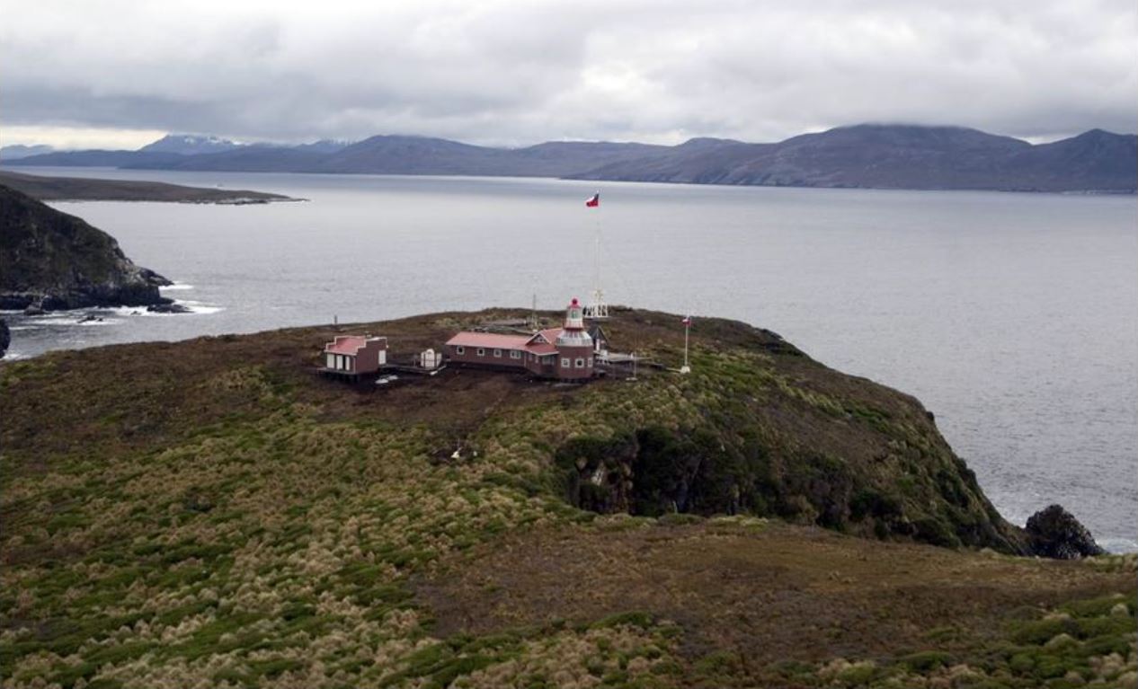
| The construction of the first lighthouse started in 1959 and it was located in the southernmost point of the Hornos island. Later, on 2 November 1962, the Cape Horn Lighthouse was inaugurated.
Afterwards, and due to the importance given by the international maritime community to this part of the world and to the increase of passenger ships, it was decided to build the monumental lighthouse near the existing lookout post in the place, which is its current location since 1991. The tower used for this aids to navigation is a cast iron structure, recycled and recovered, that was built in 1900 in the Caleta Abarca Shipyard and Dockyard workshop, in Viña del Mar. The structure was built to be used in the Punta Lavapié lighthouse in Talcahuano city (central area of Chile) which was inaugurated on 1 September 1902. In 1987, after 85 years of operation and due to the high degree of deterioration, it was replaced by a modern fiberglass tower of 4 meters. The Hornos Island monumental lighthouse was inaugurated on 17 November 1991. Later, on 6 January 2006, the tower of the lighthouse was modified and a house for the lighthouse keeper’s family was built. The structure of the tower was modified adding 4.5 meters of cast iron, which meant a total height of 61.5 meters above sea level and a tower of 11.5 meters high, keeping the other characteristics of the lighthouse. The family house was built with a modern style that is compatible with the architecture of the lighthouse’s tower. Both structures were designed with the purpose to be visited, allowing tourists that come to the island to be able to observe the immensity of the place in a safe way. |
Reason For Nomination
| (Text extracted from nomination form submitted by Chilean Navy in 2021) |
| Intrinsic Heritage Interest of the Lighthouse
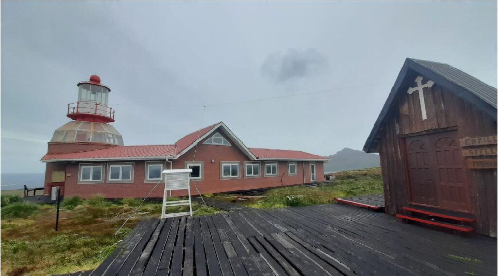
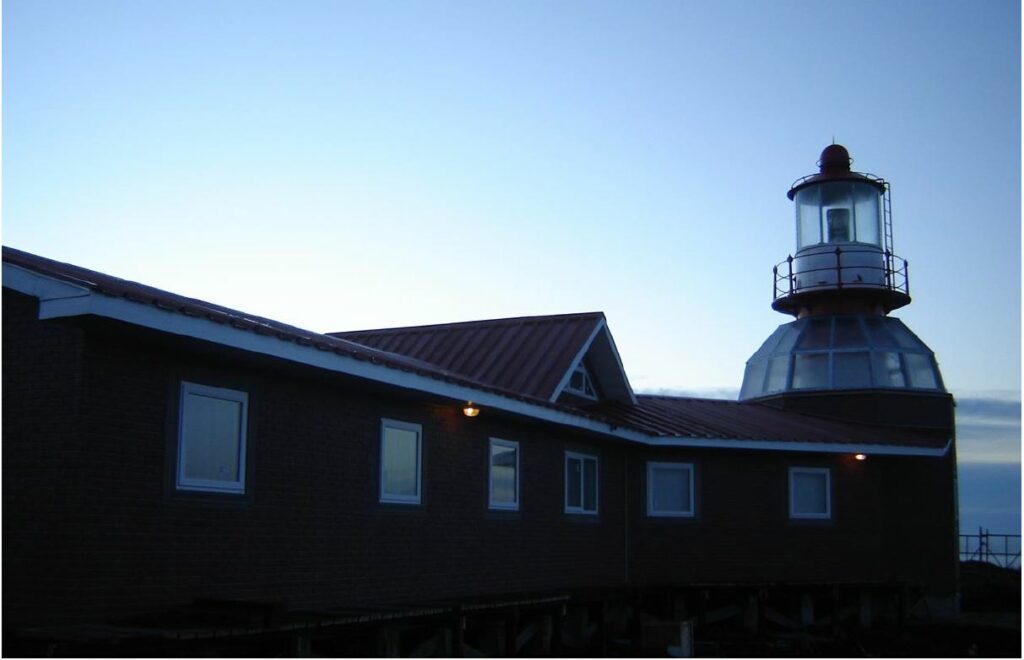
Location The Cape Horn marks the northern boundary of the Drake Passage that separates the continent of America with the Antarctica and connects the Pacific with the Atlantic Ocean. The Cape Horn is part of Chile’s territorial sea, country that exercises sovereignty in the island. It belongs administratively to the Cape Horn district and its Capital is Puerto Williams, which is also the capital of the Chilean Antarctic Province in the Magallanes and Chilean Antarctic Region (XII Region). Biosphere reserve Context of the lighthouse construction However, with the opening of the Suez canal in 1869, the Panama canal in 1914 and the construction of roads and trains in other countries of the continent, merchant shipping in the Cape decreased significantly. Today is being used by large vessels that because of their size are not allowed to navigate through channels, such as aircraft carriers or oil supertankers. Although many years have passed since the opening of the Panama and Suez Canal, navigation through the Cape Horn has continued to be one of the fastest alternatives to go around the world. Over the years, it has increasingly been used as a long distance maritime route for recreational purpose. For its remote location and dangerous navigation, to round the Cape Horn has become one of the most exciting experiences for sailors, one that can be compared to climbing the Everest for climbers. The new situation of Cape Horn represented by an increasing number of passenger, recreational and fishing vessels and the importance that the international maritime community gives to this part of the world, led to national authorities to increase safety of navigation. Thus, the main concerns for the construction of the lighthouse were the dismembered and large geography of the area, adverse weather conditions and the responsibility for the safety of the maritime traffic operating between the Pacific and the Atlantic Ocean and between the continent and the Chilean Antarctic territory. Operation The house was designed for the only family living in the island, the lighthouse keeper’s family, who stays in the island for one year and is provided with supplies by the Chilean logistic centres near Puerto Williams, a populated town located a few hours of navigation from the island. The house has a radio, radar and maritime traffic control room, the main functions of the station today are maritime communication, maritime traffic control, location of surface contacts detected in the horizon, real-time data collection and broadcast of weather conditions in the area, and it also operates as a Permanent Warning Centre in case the Search and Rescue Service activates an alert. Regarding the very adverse weather conditions, the station has been provided with up-to-date equipment to broadcast via internet real-time meteorological data useful for sailors, such as barometric pressure, temperature, relative humidity, direction and intensity of the wind and wave height. This information is processed by the Meteorological Service of the Chilean Navy who shares via internet weather charts and meteorological forecasts for the maritime areas of the country and the world. The lighthouse tower is an 11-meter-high cast iron structure with a lighting system at the top consisting of two 500 mm old Fresnel lens, mounted one over the other. As a light source, a lamp changer with incandescent lamps of 60 watts in each lens was installed. Both equipment synchronised can reach a light power of 3,973 candelas, which allows a nominal range of 12 nautical miles. The lighting system is powered by a nickel-cadmium battery bank charged with an electric generator. Likewise, as a complement to the automatic light signal, the lighthouse has a racon and an AIS AtoN device. |
| Conservation
Cast iron tower The structure was built to be used in the Punta Lavapié lighthouse in Talcahuano city (central area of Chile) which was inaugurated on 1 September 1902. In 1987, after 85 years of operation and due to the high degree of deterioration, it was replaced by a modern fiberglass tower of 4 meters. However, the central part of the structure resisted the pass of the years. It was removed in 1990 to be restored, which included melting some parts that were much deteriorated after many years of operation and relocations. It also considered a modification in the top of the dome. After all the modifications and adaptions, the structure had the following characteristics: cylinder shaped cast iron tower, 7 meters high and 2 meters in diameter. In 2006, the height of the tower was increased to 11.5 meters. In that same year, the house was built to host the maritime traffic control and meteorological station. Lighting equipment Hornos Island Monumental Lighthouse is very well preserved due to the maintenance provided by the lighthouse keepers and his family, in addition to the annual maintenance scheduled by the Aids to Navigation Service (Lighthouse National Authority) of the Chilean Navy, which includes the aids to navigation equipment, machinery, and facilities. |
| Public Access and Education
Navigating the last vestige of insular Chile, in the extreme south of the American continent and contemplating the beautiful landscapes of the Cape Horn National Park and adjacent islands, is a visual spectacle that captivates anyone, it is the only place in the world where the Pacific and Atlantic oceans converge, forming wild and rough currents with the vastness of the Drake Sea in the background. These special conditions in the area have generated unique sea and land ecosystems, where various species that depend on the sea multiply, and on land we find the peculiar sub-Antarctic forest that seeks to protect itself from hurricane-force winds of more than 100 km / h. The surroundings of Cape Horn and Chilean Antarctica include an enormous biodiversity of maritime and terrestrial areas where we can find animals such as the giant petrel, the magellanic penguin, the elephant seal, the southern right whale and the Peale’s dolphin, the latter can be sighted in different excursions and tours in small boats, as they usually follow them during the journey, in addition to other birds that feed and seek shelter among the great roots of the existing vegetation on the island. The waters that surround Cape Horn are very dangerous due to the sea currents and the strong winds in the area, but with the right conditions it is possible to navigate it and contemplate the landscapes that surround it. For adrenaline lovers, in Puerto Williams and Punta Arenas (closest towns), sporting events such as yacht regattas and tourist kayak trips are held to discover their unspoiled landscapes. Despite the remoteness and complexity of the sector, the southern area of Chile is one of the most impressive natural places that people can visit. Over time this has caused a growing interest in visiting the area, so the tourist maritime routes have been promoting the place by themselves, attracting every year a significant number of visitors from all over the world, who crown each trip with a visit to the lighthouse where they are always welcomed and very well attended by the Lighthouse specialist and his family. Already on the island, it´s not an easy access to the lighthouse, but there are landings in the route and in the plain where the visitor can observe how the diversity of the flora can be combined with the rugged environment of the landscape, despite the natural difficulties from the extreme weather, in these latitudes you can see an exquisite wild flora and fauna. Due to the bad weather conditions during winter, the park can be visited from 20 November to 15 March each year, dates in which the cruise season is open and visits are allowed from 6:30 am to 9:00 pm, during this time. The latest statistical control provided by Cape Horn indicates that 67,709 passengers circumnavigated the island, 5,970 people visited the place and a control of 694 ships was carried out to passenger cruise ships, merchant ships and sailboats. |